
Land grabbing
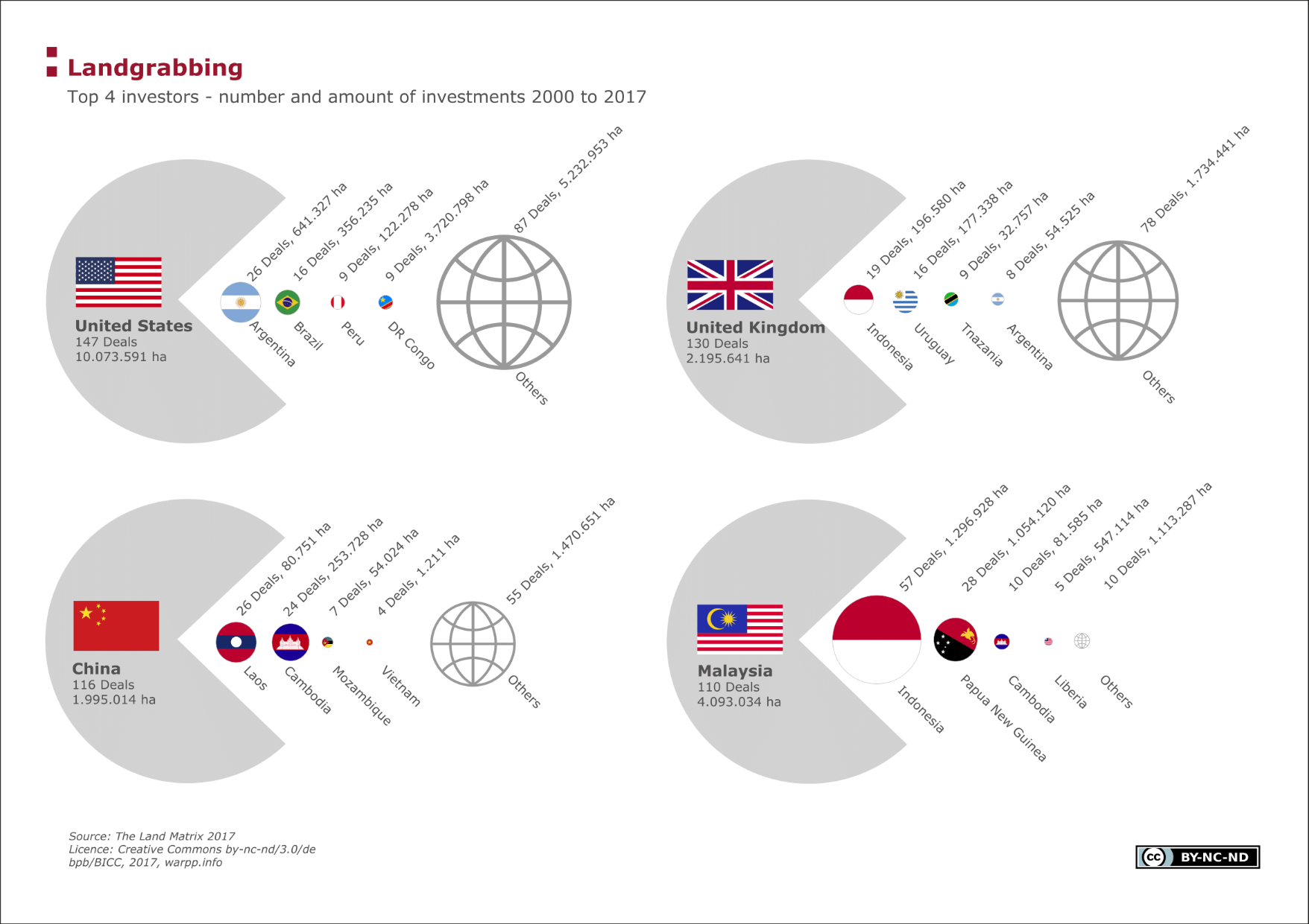
The diagram gives information on the four most important countries of origin for large-scale acquisitions of land – often referred to as land grabbing – and their target countries. Since the financial crisis, in particular, investments in land (arable land, forest, nature reserves, etc.) have evolved into much-in-demand investments. Corporations and states alike buy or lease large amounts of land – often to the disadvantage of the population living there.
Facts
Based on estimates from the World Bank, 10 to 30 per cent of arable land worldwide is now affected by land grabbing. If we take a closer look at the investments, it is noticeable that agricultural areas in some East African and south-east Asian countries have been primary targets of transnational investors. A significant portion of both private and state investors come from western Europe, the Gulf States, the United States, China and Malaysia. Data from the Global Land Matrix (see below) were analysed; it should be noted that the data shown may not reflect the reality of the situation.
In terms of the number of transnational deals, Great Britain and the United States are the most important investing countries, followed by China and Malaysia. It is striking that an especially large number of deals (almost 15 per cent of British and more than 50 per cent of Malaysian) take place in Indonesia. Other major target countries are Cambodia and Laos, as well as Argentina.
Terms, notes on methodology or reading aids
Land grabbing is defined as the purchase of large areas of agricultural land in less developed countries by private investors and state actors from industrial and emerging economies by means of long-term lease or purchase contracts. In the last few years, more and more capital is invested in eastern and western Europe. The land is mainly used to grow food or energy crops for export to the investing countries for food and energy security. Other motives of foreign investors are securing sources of freshwater and natural resources. The negative tone of the term land grabbing can be traced back to its negative effects, such as the destruction of small farmers’ livelihoods, a lack of food production for local populations, low wages for local workers or large-scale environmental degradation, for example by monocultures with intensive use of pesticides and mineral fertilisers.
The data are obtained from the Land Matrix Database (version: 14.01.2015). Deals that can only be found in media reports are not taken into consideration. The details of the areas relate to the details given in the text of the contracts – the actual area can often deviate from this so that there is some uncertainty in relation to the correctness and verifiability of the data.
Data sources:
The Global Land Matrix The Global Land Matrix is a global and independent initiative. Its goal is to bring transparency to the worldwide business of land grabbing. The Land Matrix database contains investments from the year 2000 onwards and currently contains close to 1,000 entries, not including media reports. The crowdsourced database is supported and coordinated by many international organizations such as, for example, the Deutsche Gesellschaft für internationale Zusammenarbeit (giz) (“German Association for International Cooperation”) as well as economic institutes. When interpreting the data it should be noted that these may not correspond 100 per cent to reality. Many deals could not be entered into the database due to a lack of information and some deals even fall through. http://www.landmatrix.org
For a detailed overview of data and data sources, refer to module "Environmental Safety”, sub-category “Land Grabbing”.
")
")
")